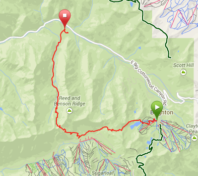
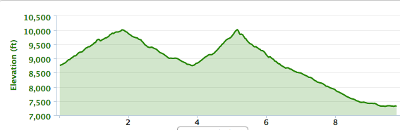
Rather serious trail and road run. 16 miles, 4000'+ up, 4000'+ down. From Brighton, up Milly, through SolBright to Twin Lakes Pass, down to Alta, up Cardiff Pass, down the BCC side into Cardiff Fork. This part was a little treacherous, as I had to sidestep across some very steep snow slides, which I'm not a fan of. Down into Cardiff road eventually, a little loop of that campsite right before Big Cottonwood Road, and then Garmin died .2 miles from the road (9.8 on the Garmin). Then, 5.8 miles back up the road with a .2 mile venture into Spruces to refill water. The road portion was longer and steeper than I remembered and I really pushed myself hard on the 2nd big climb (Cardiff), so I was really out of it on the road and even had to walk a couple of the steepest sections. Finished in sort of a daze, but hey, that sometimes happens when getting endurance back and doing 2 1/2 + hour outings. Total drop was 3990' in the first 9.8, and I'm sure I had more than 10' of drop in the last 6.2 miles, even with an almost pure uphill, so given a loop and equal up down, total gain and loss were both somewhere between 4000' and 4100', ie, not easy. My feet held up fine in the 5.x oz Shay XC shoes, but I found myself being quite careful on rocky sections, so I'll just get some Kinvara TR2s for Speedgoat in a month.
GPS of the first 9.8:
Elevation of the first 9.8:
The last 6.2 miles really sucked. I seemed to recall Brighton being 8500 and Mill D being 7800, for 700' of climb on the road, not 8750 and 7300 for 1450' of climb. Hah.
| 